The Great Lakes Were Not Empty: Underwater Stone Lines, Ancient Canoe Highways, Mound Cities, Lost Maps, and the Suppressed Edge of North American History
A Pattern Nexus deep dive into Great Lakes ancient sites, underwater stone structures, Lake Mendota’s canoe field, Cahokia, Aztalan, Old Copper networks, early Chicago maps, DuSable, fringe Egyptian claims, buried artifacts, and the bigger question: how much older and more connected was North America than the public story admits? A deep Pattern Nexus article on ancient Great Lakes archaeology, underwater stone lines, Lake Michigan Stonehenge, Lake Huron hunting structures, Lake Mendota canoes, Cahokia, Aztalan, Old Copper trade, early Chicago maps, DuSable, Egyptian artifact claims, and disputed alternative history.
 Pattern Nexus Research
Ancient Great Lakes / Buried America / Signal vs Archive
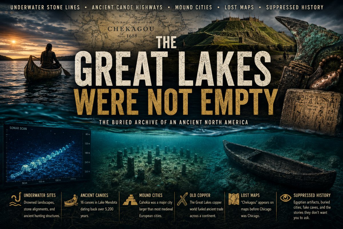
The Great Lakes Were Not Empty
Underwater stone lines. Canoe fields older than the pyramids. Copper routes running out of Lake Superior. A city at Cahokia larger than most people were ever taught. Chicago appearing on maps before it was Chicago. DuSable erased behind the later settler myth. And then, sitting around the edges, the stories nobody wants to touch cleanly: Egyptian artifacts, Phoenician claims, Wisconsin pyramids, buried cities, fake caves, missing context, and a whole older signal buried under the official timeline.
Quick Read
The Great Lakes were not some empty wilderness waiting for European settlement. They were a lived-in, engineered, traveled, traded, mapped, remembered, and repeatedly overwritten landscape.
The Problem With the Official Frame
The Great Lakes story is usually told like this: glaciers, forests, tribes, French explorers, fur trade, Fort Dearborn, Chicago, industry, modern America. Clean. Linear. Safe.
But that frame leaves too much out. It does not explain why there are drowned landscapes under the lakes that preserve ancient stone structures. It does not explain why Wisconsin lakes are now producing ancient dugout canoes in clusters, not isolated finds. It does not explain the scale of Cahokia. It does not explain how copper from the Upper Great Lakes moved through continental networks. It does not explain why Chicago appears as a named place before it was a city, because the place already existed in Indigenous geography before it existed in European settlement records.
And then there is the other layer: the rumors, the old newspaper stories, the alleged Egyptian artifacts, the Wisconsin pyramid stories, the “lost race” books, the Burrows Cave mythology, the buried-city claims, and the amateur reports that float around the edges of accepted archaeology.
Most articles do one of two lazy things. They either accept every fringe claim as proof of a suppressed ancient civilization, or they mock everything outside the approved archive and move on. Neither method is good enough.
The Evidence Ladder
For this article, the claims need to be sorted into layers. Not everything belongs in the same bucket. A radiocarbon-dated canoe is not the same thing as a local legend. A NOAA-documented submerged hunting structure is not the same thing as a private artifact with no chain of custody. A hoax does not erase the entire pattern around it, but it does tell us where the record has been polluted.
| Layer | What It Means | Great Lakes Examples |
|---|---|---|
| Confirmed | Documented by archaeology, mapped, dated, or held in official collections. | Lake Mendota canoes, Cahokia, Aztalan, NOAA Lake Huron sites, Chicago 1688 map record. |
| Strong but Developing | Real site or feature, but interpretation still under debate or incomplete. | Lake Michigan stone line / “Stonehenge” site, broader submerged landscape models. |
| Possible / Unresolved | Reported but not fully documented, or lacking enough public data to lock down. | Some submerged stone formations, old artifact reports, buried-site claims. |
| Contaminated | Some real geography or local memory exists, but the claim has been distorted. | Rock Lake pyramids, Aztalan-Aztec naming myths, “lost race” mound explanations. |
| Likely Hoax | No chain of custody, forged artifacts, contradictory story, private control of evidence. | Burrows Cave, many “Egyptian Midwest” tablets, private exotic-inscription collections. |
That is the only way to do this honestly. Keep the door open where the evidence is incomplete. Close it where the evidence is obviously manufactured. But do not let one fake cave become an excuse to ignore an entire ancient regional system sitting in plain sight.
The Underwater Great Lakes Layer
The most important clue is water level. The Great Lakes were not always the Great Lakes in their modern form. Shorelines moved. Land bridges existed. Hunting grounds drowned. Travel corridors disappeared. That matters, because submerged archaeology does not behave like land archaeology. It can preserve an older world by burying it under water, sediment, and silence.
Lake Michigan: The “Underwater Stonehenge” Problem
The popular version says there is a “Stonehenge” under Lake Michigan. That is not quite right, and that correction matters. The media label is misleading. It is not a European-style megalithic henge. The stones are relatively small, and the site is better described as a long line of stones extending over a mile.
But correcting the label does not make the site unimportant. In fact, it may make it more important. A mile-long stone line under Lake Michigan is still a signal. If it was a prehistoric drive line, hunting structure, ritual boundary, route marker, or something else, the public story still has to deal with the same basic problem: people were organizing the landscape in a place that is now underwater.

Lake Huron: Alpena-Amberley Ridge
Lake Huron is the cleaner scientific case. The Alpena-Amberley Ridge is a landform that was once dry land and is now submerged in the middle of Lake Huron. The ridge preserves evidence of cultural occupation dating back to the last Ice Age, including ancient stone structures, artifacts, and environmental material.
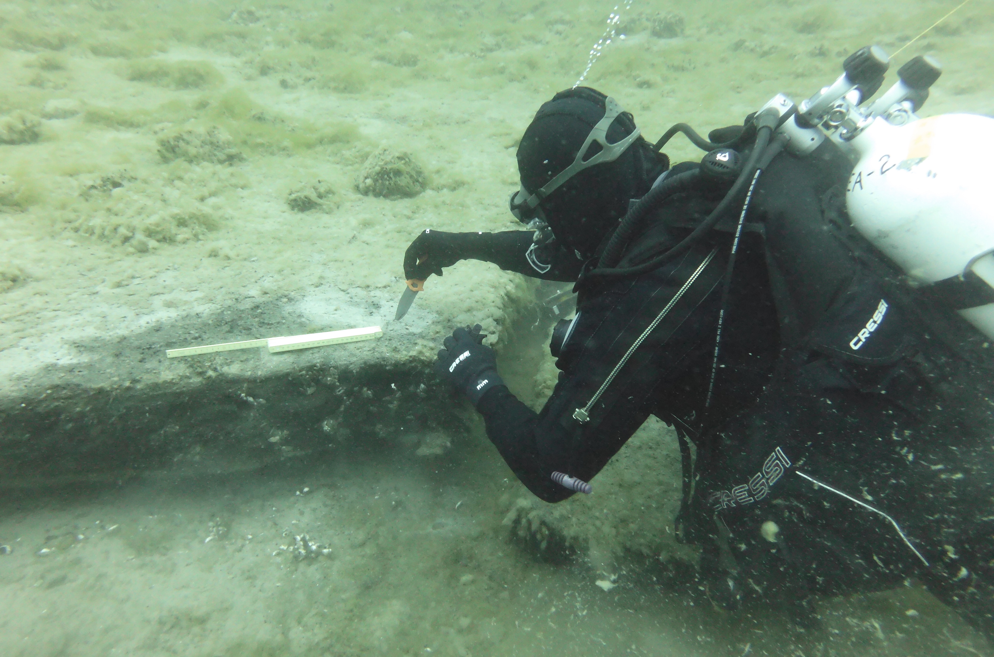
That is not fringe. That is the official archive admitting that under the lake there are intact ancient landscapes from a time when people were moving through what is now open water.
Lake Mendota and the Canoe Highway
The Lake Mendota canoe discoveries are one of the strongest recent signals in the whole Great Lakes story. Archaeologists have identified 16 ancient canoes submerged in Lake Mendota near Madison, Wisconsin. The oldest is about 5,200 years old. The site has been described as a prehistoric “parking lot” because the canoes appear to have been left in a recurring use-zone near old trail networks.
This is where the story changes. One canoe can be an accident. Two canoes can be a coincidence. Sixteen canoes across thousands of years is a system.
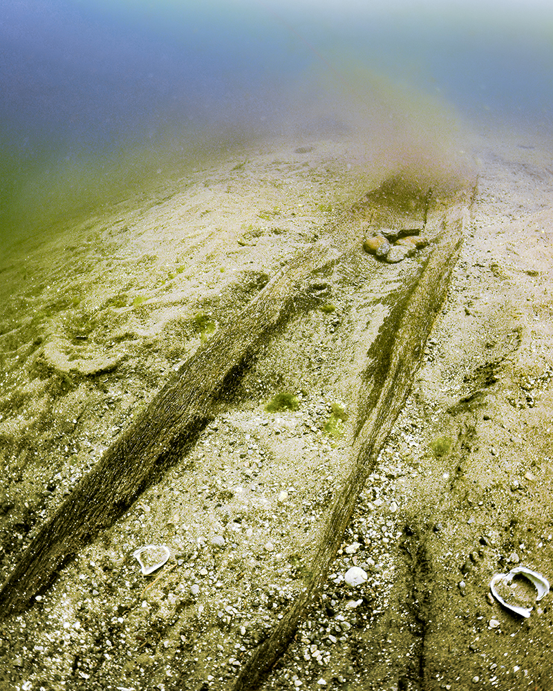
The practical interpretation is straightforward. Canoes could have been stored in shallow water or buried in sediment so they did not dry out, crack, freeze, or disappear. The bigger implication is not just boat storage. It is mobility. It means these people were using water as infrastructure. The lake was not a barrier. It was a road.
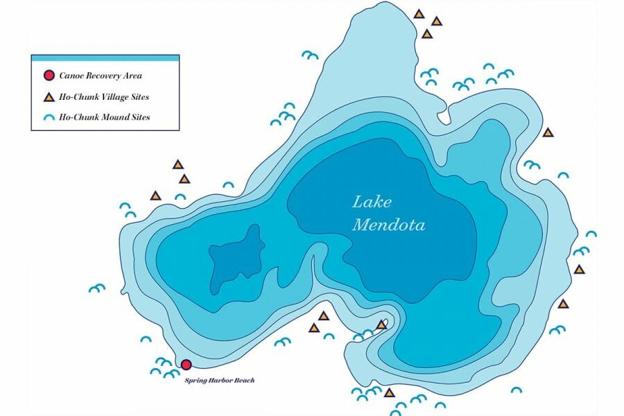
This is also where Indigenous memory and archaeology start lining up instead of fighting each other. Ho-Chunk voices have emphasized that these finds show how long their people have been connected to the waters and lands. The Madison area, Dejope, was not a scattered temporary camp story. It was a lived Indigenous landscape with routes, lakes, springs, villages, spiritual geography, and continuity.
Old Copper and the Industrial Signal
The Upper Great Lakes copper story is one of the least appreciated ancient technology stories in North America. Native copper existed in the Lake Superior region in a form that could be worked without smelting. Ancient people quarried, collected, hammered, annealed, shaped, used, traded, and symbolized it.

The Old Copper Complex is not a little side note. It is a technological layer. Copper from the Great Lakes moved into tools, spear points, knives, awls, ornaments, and status goods. The key sites and regions include Isle Royale, the Keweenaw Peninsula, the Upper Peninsula of Michigan, northeastern Wisconsin, and burial / artifact contexts like Oconto.
Here is where the alternative crowd sometimes jumps too far. Yes, Great Lakes copper matters. Yes, it moved. Yes, there are old theories about copper going far beyond the continent. But the strong evidence already gives us a major story without needing to force Egypt into every gap.
| Material | Likely Source / Corridor | What It Shows |
|---|---|---|
| Native copper | Lake Superior / Isle Royale / Keweenaw | Mining, working, exchange, and symbolic value. |
| Marine shell | Gulf Coast via Mississippi systems | Long-distance exchange reaching inland mound centers. |
| Mica | Appalachian sources | Hopewell / ceremonial exchange networks. |
| Obsidian | Western sources | Extremely long route connectivity when verified in context. |
| Chert / stone tools | Regional quarries and river routes | Practical trade and tool movement across watersheds. |
Cahokia Was the Urban Node
Cahokia is the part that should have broken the simplified American history story a long time ago. Near modern Collinsville, Illinois, across from St. Louis, Cahokia was the largest pre-Columbian settlement north of Mexico. It covered a massive area, contained major mounds, and reached a population scale that makes the word “village” ridiculous.
That is not a camp. That is not a loose village. That is a city-scale ritual and political center.
Monk’s Mound dominates the site. It is a massive earthen platform mound, built in stages, rising about 30 meters high. Cahokia also had plazas, palisades, residential zones, specialized activity areas, satellite settlements, and Woodhenge-style post circles used as astronomical / ceremonial markers.
The trade angle matters. Cahokia sat near one of the most important river junction systems on the continent. Mississippi, Missouri, Illinois, Ohio, Wisconsin, and Great Lakes corridors could all connect into larger movement networks. Copper, shell, stone, mica, food, pottery, ritual objects, people, marriage ties, stories, authority symbols, and ceremonial knowledge could move through that system.
Aztalan, Wisconsin Mounds, and Local Memory
Aztalan in Wisconsin matters because it sits in the bridge zone between the Great Lakes world and the Mississippian world. It had platform mounds, a palisade, houses, and connections to the broader Mississippian system. It was not Aztec, despite the name. That name came from early settler interpretation, where people were trying to explain impressive earthworks through Old World or Mesoamerican comparisons instead of allowing Native North America to have its own complexity.
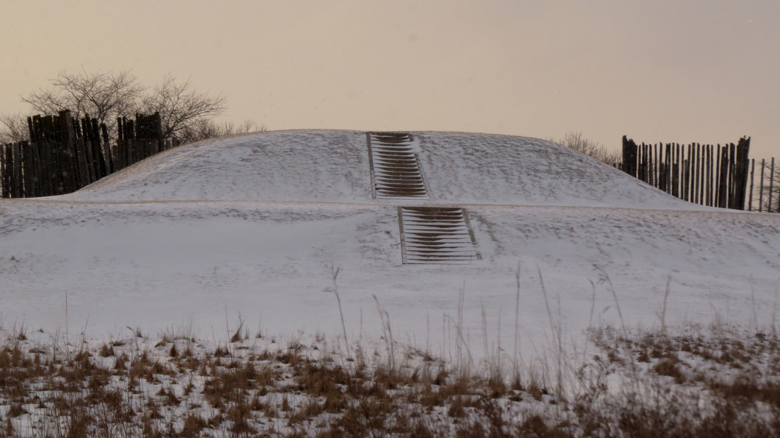
The same thing happened across the mound-builder debate. For a long time, many Euro-American writers did not want to credit Indigenous people with building the mounds. So they invented “lost races,” vanished white civilizations, Hebrews, Egyptians, Phoenicians, Romans, Vikings, Atlanteans, and whatever else fit the cultural imagination of the time.
That history matters because it cuts both ways. On one side, mainstream institutions used the correction to restore Indigenous authorship. That is good. On the other side, the correction sometimes became a blanket tool to dismiss every anomaly, every local report, every amateur discovery, and every uncomfortable artifact claim as racist nonsense or hoax material before it is even sorted.
Chicago Before Chicago
One of the most overlooked parts of this entire story is Chicago itself. Chicago shows up as “Chekagou” on a printed map in 1688, before it was settled as the modern city. That does not mean there was a hidden skyscraper city. It means the place already existed as a named Indigenous geography before the American city existed as a legal and commercial machine.
This is important. Maps do not create every place they name. Sometimes maps copy names from older networks. A European cartographer marking “Chekagou” is not inventing Chicago out of thin air. He is recording a place that already had identity, route value, and meaning inside Native geography.
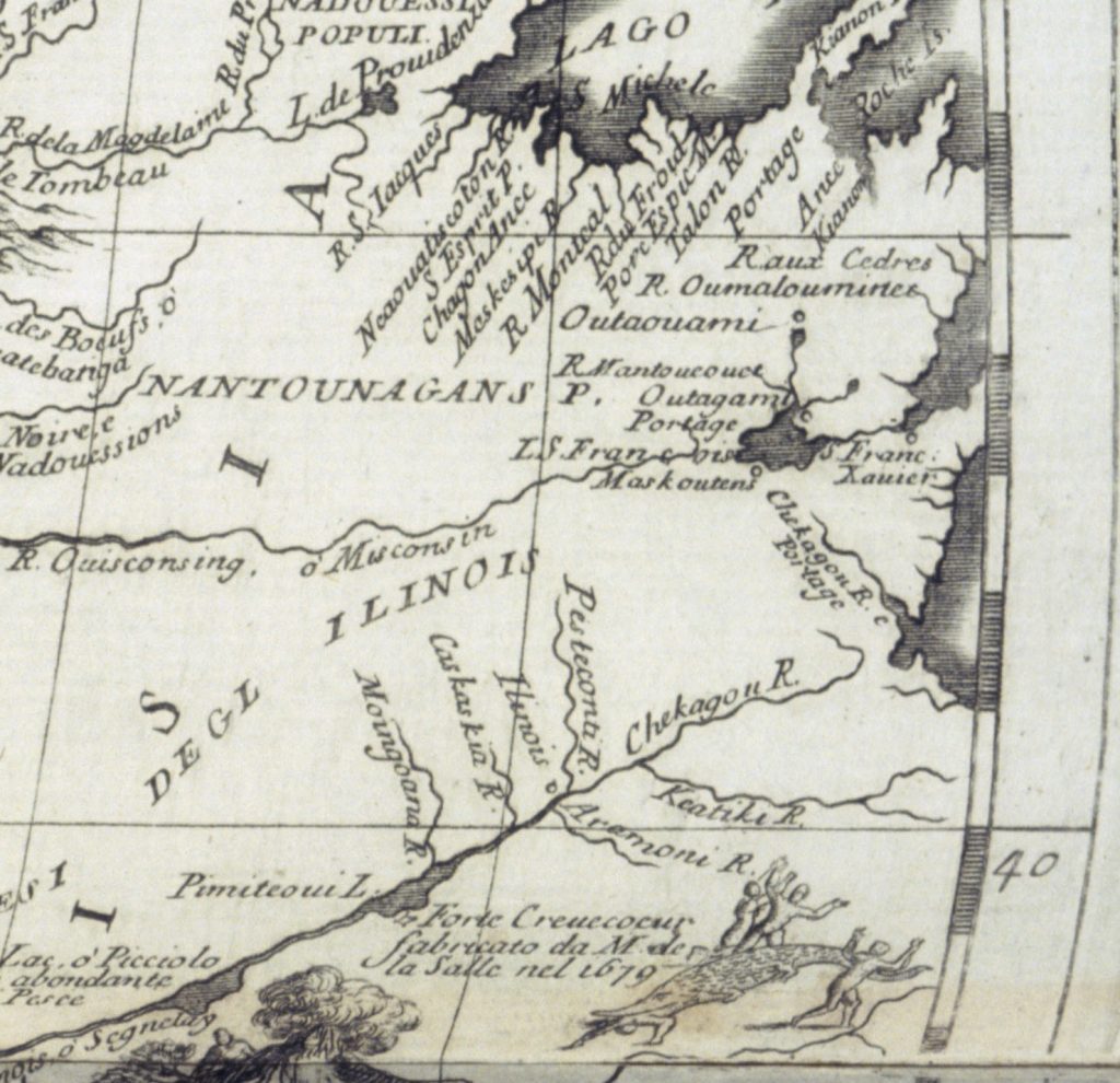
Chicago’s strategic value is obvious when you stop looking at it like a modern city and start looking at it like a water-transfer node. The Chicago River, Lake Michigan, portage systems, Des Plaines, Illinois River, Mississippi access, and Great Lakes access made the region a hinge between watersheds.
That means the deeper Chicago story is not “settlers found a swamp.” The deeper story is that a place already known inside Indigenous route geography became the control point for a later imperial, commercial, rail, grain, meat, finance, and logistics machine.
DuSable and the Erased Founder Layer
Chicago’s first permanent non-Indigenous settler was Jean Baptiste Point DuSable, a man of African descent, born in Saint-Domingue, present-day Haiti. He established himself in the Chicago area by the late 1770s and married Kitihawa, also known as Catherine, a Potawatomi woman.
This matters because the public imagination of Chicago is usually built through later names: Fort Dearborn, Kinzie, railroads, meatpacking, industry, Al Capone, the Board of Trade, skyscrapers, machine politics. DuSable gets mentioned, but often as a footnote. That is not an accident. It is the same archive behavior you see everywhere else: the route existed before the empire; the Indigenous name existed before the city; the Black founder existed before the white civic myth hardened.
10. The Ancient Trade Network
The strongest version of the Great Lakes ancient-trade theory does not require Egyptians. It starts with geography.
The Great Lakes are not isolated lakes. They are connected to rivers, portages, marshes, inland lakes, glacial corridors, copper sources, fish runs, wild rice areas, hunting grounds, mound centers, and later colonial trade paths. Ancient people did not need paved roads to build networks. They had water.
Known / Plausible Movement Spine
Lake Superior copper → Upper Peninsula / Wisconsin routes → Lake Michigan / Fox-Wisconsin portage systems → Illinois River → Mississippi corridor → Cahokia / Hopewell / Mississippian exchange world.
South-to-North Return Signal
Gulf shells, ceremonial goods, maize-world influence, Mississippian iconography, pottery styles, marriage ties, ritual authority symbols, and social templates moving back into northern nodes.
This is what “ancient trade route” should mean before it becomes fantasy. A real continental system existed. It may have been more extensive than the public story admits. It may have had older roots than the clean textbook periods imply. But the starting point is already strong: water highways, copper, shell, mounds, canoes, and named places.
Egyptian Claims, Wisconsin Artifacts, and the Hoax Problem
Now the uncomfortable layer.
There are persistent stories about Egyptian artifacts in Wisconsin, Egyptian or Phoenician links to the Great Lakes, lost colonies, tablets, inscriptions, ancient Old World visitors, and “suppressed” finds. Some of these stories are old. Some are tied to newspaper accounts. Some come from private collectors. Some come from fringe authors. Some are obvious frauds. Some are just poorly documented.
The most important thing is not to treat all of them the same.
Rock Lake Pyramids
Rock Lake near Aztalan has a long local mythology around underwater pyramids. The story is powerful because the geography is already interesting: Aztalan nearby, mounds nearby, water nearby, old settlement layers nearby. But the pyramid claim itself has not held up cleanly. Reports change in number and description. Some accounts involve children diving on a breath. Later interpretations point toward glacial stone piles, rubble, or natural features rather than built pyramids.
Still, Rock Lake should not be thrown away entirely. The pyramid claim may be weak, but the region’s deeper archaeology is not weak. That is the distinction.
Burrows Cave
Burrows Cave is the classic contaminated claim. Alleged Egyptian, Phoenician, Hebrew, Roman, Christian, and other Old World artifacts. Secret cave. Private control. No stable public excavation. No proper chain of custody. Many objects viewed as crude or forged. Even some alternative-history supporters rejected it.
Burrows Cave should be treated as a warning label. It does not prove Old World contact. It proves how fast a real public hunger for buried history can be hijacked by bad evidence.
The Egyptian Artifact Problem
The harder category is the scattered “Egyptian artifact” claim. Most do not have clean context. No controlled dig. No documented stratigraphy. No museum-grade chain of custody. No reliable dating. No independent lab verification. Sometimes the object is missing. Sometimes the photo is bad. Sometimes it is in a private collection. Sometimes the inscription is claimed to be “Egyptian” by someone who does not read Egyptian.
That does not mean every object is fake. It means the public cannot use it as proof yet.
| Claim Type | Problem | How To Treat It |
|---|---|---|
| Private Egyptian tablet | No excavation context, uncertain script, no dating. | Interesting lead, not proof. |
| Old newspaper artifact claim | May be exaggerated, misidentified, or lost. | Track original article, location, collector, museum path. |
| Underwater pyramid report | Visibility, geology, memory drift, changing accounts. | Needs sonar, coordinates, dives, geological review. |
| Buried city rumor | Often no map, no dig record, no artifact set. | Compare with known mound / village / earthwork records. |
| Confirmed mound / canoe / copper site | Interpretation may vary, but site is real. | Use as the foundation of the article. |
What It Could Mean
The safe version is: Great Lakes archaeology is richer than most people realize.
The Pattern Nexus version is deeper: the public timeline is not wrong because every fringe claim is true. It is wrong because it compresses complexity. It shrinks the continent. It turns water highways into wilderness. It turns cities into “mounds.” It turns Indigenous engineering into “primitive culture.” It turns Black founding presence into a footnote. It turns old maps into curiosities. It turns ancient copper into trivia. It turns underwater landscapes into weird headlines instead of a whole missing terrain layer.
The Great Lakes were a control zone long before modern control systems arrived. Water, copper, portage, fish, rice, stone, ritual, settlement, astronomy, trade, burial, and memory all overlapped there.
So the real article is not “Egyptians built Wisconsin.” That is too small and too easy to dismiss. The real article is this:
North America was older, more connected, more engineered, more mapped, and more urban than the public story was built to admit.
That does not require pretending every fringe story is real. It requires refusing to let bad fringe evidence bury the real mystery sitting underneath it.
Source Stack
Sources are placed here only, so the article body stays clean.
- Dr. Mark Holley — The Truth About the “Stonehenge” in Lake Michigan
- NOAA Ocean Exploration — Discovering the Submerged Prehistory of the Alpena-Amberley Ridge in Central Lake Huron
- Associated Press — Wisconsin archaeologists identify 16 ancient canoes in prehistoric “parking lot”
- UNESCO — Cahokia Mounds State Historic Site
- Field Museum — Who Was Jean Baptiste Pointe DuSable?
- Newberry Library — Mapping Chicago and the Midwest, 1688–1906
- Wisconsin Historical Society — Archaeology, Aztalan, canoe, and mound records
- State / regional natural resource and archaeology references for Great Lakes geography and Old Copper context
What's Your Reaction?
 Like
0
Like
0
 Dislike
0
Dislike
0
 Love
0
Love
0
 Funny
0
Funny
0
 Wow
0
Wow
0
 Sad
0
Sad
0
 Angry
0
Angry
0

Founder of Pattern Nexus. I research markets, macro, geopolitics, AI, history, ancient systems, and the patterns most people overlook. I’m also building Market Radar, a trading scanner designed to read pressure, risk, confirmation, and setup quality before chasing a move. Pattern Nexus is where I connect the dots between data, history, technology, and the bigger system playing out around us.






Comments (0)