Earth’s Missing Civilizations: The Silurian Hypothesis, Younger Dryas Shock, and the Ghost Trail of Human Deep Time

A deep Pattern Nexus investigation into the possibility of earlier civilizations on Earth, using the Silurian Hypothesis, the Younger Dryas climate reversal, impact-marker research, Göbekli Tepe interpretations, sea-level rise, submerged landscapes, and the limits of geological evidence. The real question is not whether ancient humans had modern technology. The deeper question is whether Earth’s surface is capable of preserving the kind of civilization we would expect to find.

Jun 04, 2026 - 00:55
Updated: 1 day ago
0 8
Earth’s Missing Civilizations: The Silurian Hypothesis, Younger Dryas Shock, and the Ghost Trail of Human Deep Time
A Pattern Nexus premium research image showing Earth’s deep-time record as layered sediment, with possible traces of lost civilizations, Younger Dryas climate disruption, impact markers, rising seas, and Göbekli Tepe-style astronomical monuments.
Support Independent Pattern Nexus Research
Deep macro plumbing, liquidity mechanics, and system analysis. No sponsors. No paywalls.
Support Pattern Nexus
Independent macro research and system-level analysis. No sponsors. No paywalls.
Premium Quick Read

The video opens with the right instinct: the human story is probably not as clean as the textbook staircase makes it look. The mistake is usually not curiosity. The mistake is scale. People hear “lost civilization” and jump straight to Atlantis, flying machines, nuclear reactors, or ancient astronauts. That is the wrong entry point. The real question is sharper and more dangerous: what kind of human complexity can Earth erase?

Earth is not a passive record keeper. Earth is a shredder. Coastlines move. Ice sheets scrape. rivers cut. deserts bury. jungles rot. oceans rise. sediments compress. plates subduct. chemistry transforms. The surface is recycled over and over again. The deeper the timeline, the more the record becomes a survivor set, not a full archive.

That means the absence of obvious ruins is not a complete answer. It is only one data point. A civilization made of concrete, steel, plastics, fossil fuels, rare metals, nuclear isotopes, and global mining leaves one kind of trace. A civilization made of timber, reed, rope, shell, hide, mudbrick, oral maps, ritual calendars, seasonal gathering sites, coastal navigation, and symbolic stone leaves another kind. One creates a planetary chemical disturbance. The other can disappear into ocean, mud, memory, and myth.

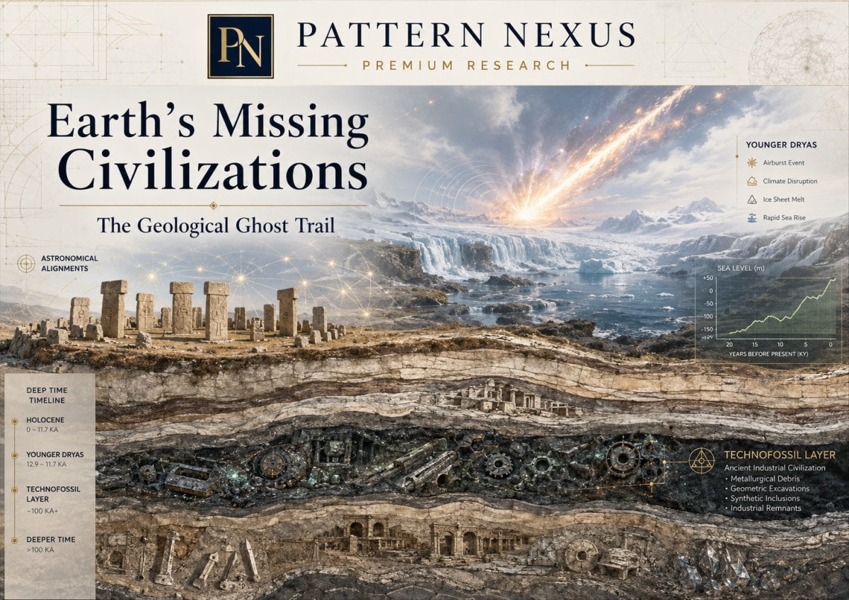
The Silurian Hypothesis gives this question a scientific spine. Gavin Schmidt and Adam Frank asked whether an industrial civilization millions of years before ours would be detectable in the geological record. The answer is not comforting. Direct artifacts would be weak over deep time. The better evidence would be system disturbance: isotope shifts, altered carbon and nitrogen cycles, strange synthetic compounds, metal anomalies, combustion residues, extinction patterns, and sedimentary discontinuities.

The Younger Dryas adds the climate-shock layer. Around the end of the last Ice Age, Earth’s warming trend was interrupted by a sudden return to colder conditions. The cause remains debated, but the effect was real enough: ecological disruption, moving climate belts, stressed food systems, megafaunal decline, and human groups adapting under pressure. Whether the trigger was ocean circulation, meltwater, volcanism, impact debris, airburst, or a combination, the period sits exactly where the human story starts becoming strange.

Göbekli Tepe adds the archaeological shock. It shows that people more than 11,000 years ago could build monumental symbolic architecture, carve massive T-shaped pillars, organize labor, create ritual landscapes, and likely maintain sophisticated memory systems before the older agricultural-first model expected that level of coordination.

The Pattern Nexus thesis is simple: the strongest argument is not that a modern technological civilization vanished. The stronger argument is that the human archive is missing entire classes of complexity. Coastal worlds. ritual worlds. seasonal worlds. maritime worlds. oral-memory worlds. astronomical worlds. perishable-material worlds. Not primitive worlds. Erased worlds.

Why This Is Premium

This topic usually gets destroyed by bad framing. One side tries to turn every ancient anomaly into a lost super-civilization. The other side treats the surviving record like it is complete. Both positions are too small.

The serious way to handle this is by separating claim levels. A prior industrial civilization millions of years old is one claim. A pre-Holocene coastal culture is another. A lost maritime exchange network is another. A Younger Dryas impact or airburst is another. A symbolic calendar at Göbekli Tepe is another. Flood myths preserving distorted memory of sea-level rise are another. These cannot be smashed together and judged as one thing.

The useful frame is preservation bias. We do not see the past directly. We see what survived destruction, what was buried correctly, what did not decay, what modern search methods found, what institutions decided to fund, and what present-day categories allowed researchers to recognize. The archive is filtered before the historian ever touches it.

That is the part people miss. History is not just what happened. It is what survived long enough to be classified as evidence.

Executive Thesis

The old civilization model is too linear. It makes human history look like a ladder: hunter-gatherer, farmer, village, city, writing, state, empire, industry. But human development almost certainly looked more like a broken network: regional experiments, collapses, adaptations, ritual centers, drowned coastlines, ecological shocks, migrations, lost routes, memory systems, and repeated resets.

The Silurian Hypothesis shows that even industrial civilization becomes geologically ambiguous if enough time passes. The Younger Dryas shows that abrupt environmental pressure can reorder human life. Göbekli Tepe shows that early humans were capable of symbolic coordination and monumental architecture before the old model expected it. Post-glacial sea-level rise shows that the most attractive human settlement zones were repeatedly drowned. Doggerland, Sundaland, Beringia, Sahul’s exposed shelves, the Persian Gulf basin, and other submerged landscapes show that the human map of the Ice Age was not the map we live on now.

The strongest conclusion is not “ancient people had modern machines.” The strongest conclusion is that human complexity has been repeatedly misclassified because modern people expect complexity to look like cities, writing, metal, roads, and bureaucracy. But complexity can also look like seasonal aggregation, oral law, star navigation, ritual architecture, ecological memory, exchange networks, symbolic calendars, coastal mobility, and disaster stories preserved for thousands of years.

The real ghost trail is not one missing empire. It is a whole missing category of human worlds.

Visual Board: The Damaged Archive Model
Layer One

Deep-Time Industry

If an industrial civilization existed millions of years ago, its strongest trace would be geological disturbance, not ruins.

Layer Two

Ice Age Coastlines

The best settlement zones were often near water. Many are now underwater, buried, eroded, or unsurveyed.

Layer Three

Younger Dryas Shock

A real climate reversal hit at the edge of the Holocene, exactly where human systems begin reorganizing.

Layer Four

Megalithic Memory

Göbekli Tepe and related sites show symbolic architecture, communal labor, and ritual systems far earlier than old models assumed.

Layer Five

Myth as Compression

Flood, fire, serpent, sky, and world-ending myths may preserve distorted memory of real environmental shocks.

Layer Six

Institutional Filters

The past is also shaped by what gets funded, excavated, published, accepted, and categorized as legitimate evidence.

Visual: Evidence Survival Over Time
Time after collapse Detectability 0 1k yrs 10k 100k 1M 10M+ Direct artifacts, roads, buildings Metals, plastics, synthetic compounds Isotope / stratigraphic disturbance Extinction / biotic turnover Oral memory / mythic compression Direct evidence dies fast. System disturbance lasts longer. Meaning becomes the hardest thing to recover.

Choose Your Reading Level

Pick the version that matches how deep you want to go.

Reader-Friendly Version: What the Video Is Really Asking

The video is really asking whether the human story has missing chapters. Not little missing footnotes. Big missing chapters. Places where human beings may have built meaningful worlds that did not survive in the form modern archaeology is trained to recognize.

That question is not automatically crazy. The Earth’s surface has changed violently since the last Ice Age. Sea level was more than 400 feet lower around the Last Glacial Maximum. Whole coastal plains existed where there is ocean now. Britain was connected to Europe through Doggerland. Southeast Asia had the huge exposed landmass of Sundaland. Beringia connected Siberia and Alaska. Australia and New Guinea were part of the broader Sahul landmass. The Persian Gulf was not always the same flooded basin it is today. The map humans lived on was not our map.

That matters because humans do not randomly choose where to live. They follow water, fish, river mouths, wetlands, migration routes, shellfish beds, estuaries, and coastal plains. If you want to find early human complexity, you would look exactly where sea-level rise did the most damage.

So the real question is not: “Where are the ruins?” The real question is: “How much of the evidence field is gone before we even start looking?”

Pattern Nexus translation: The past is not missing because humans were simple. The past is missing because Earth destroys the kinds of places humans prefer to live.

The First Mistake: Thinking Civilization Has to Look Like Us

Modern people have a bad habit of measuring intelligence by modern outputs. We look for cities, writing, roads, metal tools, big agriculture, armies, legal documents, and tax systems. If we do not see those things, we downgrade the people. That is a mistake.

Human complexity can exist without looking like a state. A society can understand stars without having telescopes. It can preserve law without writing. It can navigate coastlines without maps. It can build monuments without kings. It can manage plants without industrial farming. It can coordinate seasonal gatherings without permanent cities. It can encode history inside myth, ritual, and landscape rather than on paper.

That kind of civilization is easier to erase. It does not leave archives in stone libraries. It leaves shell middens, ritual sites, fire pits, carved symbols, burial patterns, submerged camps, oral traditions, animal imagery, alignments, and scattered material traces that may not look impressive unless you understand the system behind them.

Modern Bias What We Expect What Earlier Complexity May Look Like
Writing bias Texts, tablets, records, inscriptions. Oral law, myth cycles, star memory, seasonal songs, ritual recitation.
City bias Dense permanent settlement and walls. Seasonal aggregation sites, ritual centers, coastal mobility networks.
Metal bias Bronze, iron, smelting, weapons. Stone, bone, shell, wood, fiber, adhesive, pigment, perishable technology.
Agriculture bias Fields, granaries, domesticated crops. Gardened landscapes, managed wild plants, fishing systems, seasonal abundance.
Empire bias Kings, states, bureaucracy, armies. Kin networks, ritual authority, shared cosmology, distributed exchange systems.

The Silurian Hypothesis: When Civilization Becomes a Chemical Shadow

The Silurian Hypothesis is the cleanest scientific entry point because it removes the emotional argument. It does not say a prior industrial civilization existed. It asks a stronger question: if one did exist millions of years ago, how would we know?

That question immediately destroys the childish version of the debate. Nobody should expect skyscrapers from 50 million years ago to still be standing. Nobody should expect cars, highways, power plants, or household objects to sit neatly in a museum layer. Deep time does not preserve worlds that way.

An industrial civilization would become a geochemical event. It would look like a spike in the planet’s metabolism. Fossil carbon burned fast. Metals concentrated. soils disturbed. oceans altered. species moved. extinctions accelerated. synthetic compounds introduced. energy use imprinted into the sedimentary record.

In other words, deep time does not ask: “Where is the city?” It asks: “Where is the disturbance?”

The key idea: An industrial civilization would not primarily survive as objects. It would survive as an abnormal planetary signature.
Deep-Time Marker Industrial Meaning Natural Confusion
Carbon isotope excursion Rapid release of buried fossil carbon. Methane release, volcanism, ocean events, natural carbon-cycle shifts.
Nitrogen-cycle disruption Industrial agriculture, fertilizer, soil transformation. Climate shifts, biological turnover, erosion, ecosystem collapse.
Metal anomalies Mining, smelting, refining, extraction, industrial dust. Ore bodies, volcanic ash, hydrothermal systems, natural concentration.
Synthetic chemical residues Artificial materials, plastics, persistent pollutants. Chemical alteration, breakdown, heat, pressure, incomplete preservation.
Extinction / biotic turnover Civilization-induced ecological collapse. Climate change, impacts, disease, volcanism, habitat change.
Visual: The Silurian Detection Stack
Civilization as Energy Event Fossil carbon · mining · chemistry · land transformation · biosphere pressure Atmosphere: carbon isotope shift, warming pulse, aerosols, combustion residues Surface: mines, erosion, land-use change, soil disturbance, sediment movement Oceans: acidification, nutrient shifts, anoxia, micro-particles, burial chemistry Biosphere: extinction pressure, domesticated species, invasive mixing, pollen shifts If the signal is real, it appears as a layered Earth-system anomaly, not as a buried sci-fi city.

The Younger Dryas: The Climate Shock at the Edge of Civilization

The Younger Dryas is where the story moves from deep-time speculation into human prehistory. This was not millions of years ago. This was close enough to the human transition into settlement, agriculture, ritual architecture, and regional complexity that it matters directly.

The climate had been warming after the last Ice Age. Then the system snapped backward into a cold interval for more than a thousand years. That means human groups living through the transition did not experience a simple smooth warming into paradise. They lived through instability: warming, disruption, cold reversal, ecological pressure, then renewed warming.

That kind of instability changes human behavior. It compresses groups into refugia. It shifts animal ranges. It changes plant availability. It forces new seasonal strategies. It makes storage more valuable. It makes calendars more valuable. It makes long-distance alliance networks more valuable. It makes ritual gathering more important because ritual is not just religion; it is social coordination under uncertainty.

This is the better way to understand the Younger Dryas. Do not treat it only as a climate event. Treat it as a pressure field acting on human systems.

Visual: Human Pressure During the Younger Dryas
Younger Dryas as Pressure Field climate reversal · food stress · migration · memory · coordination Climate Instability Food & Migration Ritual Gathering Sky & Calendar The pressure does not need to “invent civilization” in one move. It can accelerate storage, settlement, ritual, alliance, sky-tracking, and memory systems.

Impact, Airburst, Meltwater, Volcano: The Cause Fight Matters, but It Is Not the Whole Story

The Younger Dryas debate often gets trapped in the cause fight. Was it comet debris? Was it an airburst? Was it freshwater disrupting Atlantic circulation? Was it volcanic forcing? Was it internal climate instability? The cause matters, but the human implication does not depend on one single answer.

If the trigger was meltwater, then human groups were still living through abrupt ocean-climate reorganization. If the trigger was an impact or airburst, then human groups were living through a sky-event trauma layered onto climate shock. If the trigger was multi-causal, then the event becomes even more important because it shows how fragile the Earth system can be at transition points.

For Pattern Nexus, the key is this: the Younger Dryas sits at the boundary between Ice Age mobility and Holocene settlement. Any major shock there is not just climate trivia. It is part of the operating environment for the human transition into agriculture, monumentality, mythic memory, and regional social complexity.

Cause Model Mechanism Human-System Meaning
Meltwater / circulation disruption Freshwater affects ocean heat transport and climate stability. Seasonal systems break; food zones shift; migration pressure rises.
Impact / airburst Comet debris, atmospheric explosion, dust, fires, shock effects. Sky trauma becomes cultural memory; fire/flood myths gain physical context.
Volcanic forcing Aerosols, cooling, atmospheric chemistry disruption. Food stress, darkness motifs, migration, ritual appeasement systems.
Multi-causal transition Ice, ocean, atmosphere, ecology, wildfire, and external forcing interact. Human adaptation accelerates because the world becomes unstable in multiple ways at once.

Göbekli Tepe: The Site That Breaks the Primitive Human Cartoon

Göbekli Tepe matters because it forces people to stop talking about early humans like they were half-awake animals waiting for farming to make them intelligent. The builders were not urban Mesopotamians. They were not modern industrial people. But they clearly had symbolic order, architectural planning, labor organization, and a shared ritual system strong enough to move stone, carve pillars, build enclosures, and sustain meaning across generations.

That alone is enough to break the old model. If hunter-gatherer or early Neolithic groups could build monumental ritual architecture, then complexity did not wait for cities. Complexity was already there. It simply took different forms.

This is where the public conversation often goes wrong. The point is not “Göbekli Tepe proves Atlantis.” The point is stronger: Göbekli Tepe proves our categories were wrong. It proves humans could organize around shared symbolic architecture before the classic state/city/agriculture package was fully in place.

That changes the search pattern. We should not only look for early cities. We should look for ritual landscapes, seasonal gathering centers, symbolic alignments, carved memory systems, ancestor sites, burial zones, feasting evidence, and sky-linked architecture.

Visual: Civilization Does Not Begin in One Place
20k BP Lower seas 12.9k BP Younger Dryas shock 11.7k BP Holocene begins 9600 BCE Göbekli Tepe horizon Agriculture Regional spread Early states writing / cities / kingdoms The old model makes civilization look like a straight staircase. The better model is branching, regional, interrupted, and partly drowned. Hidden complexity curve: ritual, maritime, memory, symbolic systems, coastal networks

The Sea-Level Problem: Where the Best Evidence Went

This is the strongest grounded part of the missing-civilization argument: the Ice Age map was not our map.

At the Last Glacial Maximum, so much water was locked in ice that sea level was more than 400 feet lower than today. That exposed huge areas of land. Some of that land was marginal. Some of it was prime human habitat: rivers, estuaries, coastal plains, wetlands, hunting routes, shellfish zones, and migration corridors.

Then the ocean came back.

This is not a small detail. It means the modern archaeological record is biased inland. The most likely places for early coastal complexity are among the least accessible places now: underwater, sediment-covered, eroded, or destroyed by marine transgression.

Lost Landscape What It Was Why It Matters
Doggerland A now-submerged North Sea landscape that once connected Britain to continental Europe. Shows that inhabited human landscapes can vanish beneath shallow seas and become archaeological ghosts.
Sundaland A huge exposed Southeast Asian shelf linking parts of the Malay Peninsula, Sumatra, Borneo, and Java. Sea-level rise reshaped migration, population structure, and the human map of Southeast Asia.
Beringia A land bridge and ecological corridor between Siberia and Alaska during low sea levels. Key to migration, ecological exchange, and now-submerged archaeological potential.
Persian Gulf basin A lowland basin affected by post-glacial flooding. Potentially important for early settlement, freshwater access, and later flood-memory traditions.
Sahul shelves Expanded Ice Age land around Australia, New Guinea, and surrounding shelves. Changes how we think about coastal movement, navigation, and early settlement routes.
Visual: The Drowned Archive
Post-Glacial Sea-Level Rise as an Evidence Filter Lower sea level: exposed coastal plains Modern sea level: drowned archive Rivers Estuaries Coastal camps Ritual sites The best human settlement zones are exactly the zones most likely to be drowned, buried, or under-surveyed.

Doggerland: Proof That Whole Human Landscapes Can Disappear

Doggerland is the perfect example because it is not myth. It was real land. It connected Britain to continental Europe. It had rivers, wetlands, animals, and human potential. Today it is beneath the North Sea.

This changes the emotional weight of the lost-landscape argument. We are not talking about fantasy islands. We are talking about real submerged human environments. If a place like Doggerland can vanish from the walking map of humanity, then the absence of visible ruins on modern coastlines tells us less than people think.

Doggerland also shows the problem of evidence recovery. Underwater archaeology is hard. Marine sediment buries landscapes. currents disturb context. organic materials decay unless preserved under specific conditions. survey coverage is limited. What is missing from the record may simply be expensive to reach.

This is the model that should be applied globally. Doggerland in Europe. Sundaland in Southeast Asia. Beringia between Asia and North America. drowned shelves around Australia. coastal zones off India. lowlands near the Persian Gulf. The late Ice Age human world was full of places that later became seafloor.

Myth as Damaged Memory, Not Literal Transcript

The video’s flood-myth angle is useful if handled correctly. Myths are not literal news reports. They are compressed memory. They fold event, warning, morality, ancestry, geography, sky, trauma, and ritual into a story durable enough to move through generations.

A real flood can become a divine flood. A real tsunami can become a punishment. A real comet can become a serpent, dragon, spear, bird, or fire god. A real volcanic winter can become a story of the sun disappearing. A real coastline drowning over generations can become a tale of a lost homeland beneath the sea.

The point is not to say every flood myth comes from one event. That is too simple. The point is that myth preserves human experience in symbolic form. If many cultures preserve stories of flood, fire, sky terror, broken seasons, or drowned lands, those stories should not be used as proof by themselves, but they should be treated as signals worth comparing against geology, archaeology, and climate history.

Mythic Pattern Possible Event Memory How to Test It
Great flood Sea-level rise, tsunami, glacial lake flood, river megaflood. Compare with local sediment, submerged settlements, shoreline history.
Fire from the sky Meteor, airburst, volcanic ejecta, lightning firestorm. Look for burn layers, shocked materials, impact proxies, local destruction horizons.
World darkness Volcanic aerosols, impact dust, smoke veil, severe climate anomaly. Compare with ice cores, sulfate layers, charcoal, climate proxies.
Serpent / dragon in the sky Comet, aurora, meteor train, plasma-like sky event, symbolic astronomy. Compare motifs, sky alignments, astronomical cycles, dated event layers.

The Reader-Friendly Bottom Line

The video is right to push the question. The human story has missing pieces. The mistake is only when people force all missing pieces into one grand answer.

The better answer is more powerful: there were probably many lost human worlds. Not one global super-civilization, but many forms of complexity that did not preserve well. Coastal societies. ritual centers. long-distance exchange routes. astronomical traditions. mythic memory systems. seasonal gathering places. submerged river-mouth communities. perishable technologies. That is where the serious story is.

Modern civilization teaches us to equate complexity with machines. The ancient world may force us to relearn that complexity can also be memory, timing, movement, ecology, symbol, and shared meaning.

Non-Technical Advanced Version: The Lost-Civilization Question Has Levels

The first thing we need to do is stop using the phrase “lost civilization” like it means one thing. It does not. It is a container for several very different claims. Some are extremely plausible. Some are speculative. Some are useful thought experiments. Some are likely wrong. The power comes from separating them instead of smashing them together.

Level Claim What Would Support It PN Read
Level 1 Early humans were more symbolically and socially complex than older models allowed. Göbekli Tepe, Karahan Tepe, ritual landscapes, complex burials, symbolic systems. Strong.
Level 2 Major pre-Holocene coastal archives are missing because of sea-level rise. Doggerland, Sundaland, Beringia, submerged settlements, continental shelf archaeology. Very strong as a preservation-bias model.
Level 3 The Younger Dryas redirected human development and memory. Climate records, settlement shifts, ecological stress, subsistence change, ritual intensification. Plausible and important.
Level 4 A comet or airburst caused the Younger Dryas. Replicated impact markers, secure boundary dating, physical mechanism, global consistency. Contested but worth tracking.
Level 5 A prior industrial civilization existed millions of years ago. Artificial deep-time chemistry or a multi-proxy anomaly impossible to naturalize. Speculative, but the detection problem is real.

This ladder is the cleanest way to avoid stupid arguments. You can reject the ancient-lasers version and still accept that the human archive is damaged. You can reject a global empire and still accept submerged coastal complexity. You can be cautious about comet impact claims and still understand that the Younger Dryas mattered. You can reject a prior industrial species and still recognize that the Silurian Hypothesis exposes how weak direct evidence becomes over deep time.

The Real Problem Is Not Evidence Absence. It Is Evidence Filtering.

The phrase “absence of evidence is not evidence of absence” is usually abused. But in archaeology and geology, the deeper issue is not absence. It is filtering. The record is filtered by environment before science ever sees it.

A tropical coastal settlement built with wood and fiber does not have the same survival odds as a stone tomb in a desert. A ritual system transmitted orally does not preserve like clay tablets. A fishing culture on a drowned shelf does not preserve like an inland walled city. A seasonal gathering network does not preserve like a palace economy. The archive is unequal by design.

This means our picture of early complexity is biased toward durable things: stone, bone, ceramics, dry caves, deserts, buried mounds, and monumental architecture. It is biased against wetland worlds, coastal worlds, forest worlds, boat worlds, oral worlds, and perishable technology.

Pattern Nexus Lens: The past is not a complete dataset. It is a corrupted dataset with survival bias.
Visual: Preservation Bias Matrix
Culture Type Complexity Level Preservation Odds Modern Recognition
Stone monument builders High visibility High Easy to classify as significant
Mudbrick village networks Moderate to high Depends on climate and burial Often visible as mounds
Coastal fishing / maritime networks Potentially high Low after sea-level rise Under-recognized
Oral astronomical cultures Potentially high Low as direct evidence Often dismissed as myth
Perishable-material cultures Unknown Very low Almost invisible unless exceptional preservation occurs

Deep-Time Industry: The Silurian Hypothesis as a Warning About Our Own Assumptions

The Silurian Hypothesis is not really about ancient reptiles or sci-fi civilizations. It is a mirror pointed at modern arrogance. We assume we would obviously detect any prior industrial civilization because our own world feels so huge. But hugeness in the present does not guarantee clarity in deep time.

Look at our civilization as a future sediment layer. Cities collapse. steel corrodes. concrete weathers. plastics fragment and chemically transform. satellites in low orbit burn up. archives rot. digital memory dies almost immediately without maintenance. What remains strongest is not the stuff we emotionally associate with civilization. It is the Earth-system disturbance.

If future geologists find us, they may find the Anthropocene as a boundary: carbon isotope change, plastics, fly ash, metals, radionuclides, extinction patterns, domestic species traces, altered soils, and abrupt atmospheric chemistry. They may not find your house, your phone, your city, or your name. They may find the shock wave of our metabolism.

Now reverse that. If another industrial civilization existed far enough back, and if it was short-lived, and if its materials degraded, and if its surface traces were recycled, then detection would depend on a thin abnormal layer that might be confused with natural hyperthermal events, volcanism, methane release, ocean anoxia, or impact disturbance.

That does not prove one existed. It proves the confidence of easy dismissal is weaker than people think.

Deep Time Is a Murder Weapon

The longer the timescale, the more brutal the erasure. A thousand years can bury a city. Ten thousand years can erase wood, roads, language, and memory. A hundred thousand years can move rivers, coastlines, ecosystems, and entire settlement zones. A million years can grind landscapes into unfamiliar forms. Tens of millions of years can move plates, subduct crust, metamorphose rock, and turn surface worlds into geochemical whispers.

This matters because people talk about “evidence” as if evidence is equally likely to survive everywhere. It is not. Evidence has a habitat. It needs burial, low disturbance, durable material, chemical stability, and later discovery. Miss any of those and the signal collapses.

Timescale What Can Vanish What Might Remain
1,000 years Wooden structures, textiles, roads, most everyday objects. Stone, ceramics, metals, burials, some architecture.
10,000 years Most perishable culture, language continuity, many settlement traces. Exceptional sites, stone tools, caves, buried monuments, some genetic traces.
100,000 years Coastlines, exposed settlements, ecological context, most organic material. Durable stone, stratified deposits, isotopes, rare preserved sites.
1 million years Most landscapes recognizable to original inhabitants. Fossils, stone artifacts, geochemical anomalies, deeply buried traces.
10 million+ years Almost all direct surface evidence. Stratigraphic disturbance, isotope anomalies, fossil record disruptions.

Younger Dryas: Not Just a Climate Event, a Civilization Pressure Cooker

The Younger Dryas matters because it hit during a human transition zone. This is the period where the world is moving out of the Ice Age and into the Holocene. That is not just a climate boundary. It is the stage on which settlement, plant management, ritual architecture, and later agriculture become increasingly visible.

If you place human groups inside that instability, the logic changes. A climate shock does not have to create civilization out of nothing. It can force social innovations that were already possible. It can make calendars more important. It can make food storage more valuable. It can make ritual gathering centers socially necessary. It can make long-distance alliances essential. It can force people to memorize sky cycles, flood cycles, migration routes, and survival knowledge.

This is the bridge between Younger Dryas and Göbekli Tepe. You do not need to prove a comet carved every symbol. You only need to recognize that early monumental ritual systems appear in a world that had just gone through dramatic climate instability. That is not coincidence in the mystical sense. It is systems pressure.

Göbekli Tepe and the Ritual Engine of Settlement

The old model says agriculture made settlement possible, and settlement made temples possible. Göbekli Tepe raises the possibility that ritual gathering may have helped create settlement pressure in the first place.

Think about what a place like Göbekli Tepe requires. You need people returning to the same place. You need shared symbolic rules. You need enough food to support labor. You need leaders, ritual specialists, or coordination mechanisms. You need stoneworking knowledge. You need mythic or cosmological meaning powerful enough to justify the work. That is already complex.

If people gathered seasonally for ritual, feasting, exchange, marriage alliances, memory transmission, and sky observation, then the pressure to manage food would increase. That could push plant management, storage, and more durable settlement patterns. In that model, ritual does not come after civilization. Ritual helps generate civilization.

Pattern Nexus read: Göbekli Tepe is not important because it proves a lost empire. It is important because it shows civilization may have emerged from ritual coordination, not just farming economics.

The Calendar Question: Sky-Watching as Survival Technology

Modern people separate astronomy, religion, agriculture, navigation, and mythology into different boxes. Ancient people did not necessarily separate them that way. The sky was clock, map, memory system, ritual authority, seasonal guide, and cosmic story all at once.

If a group lives through unstable climate, changing seasons, animal migrations, flood pulses, and shifting resource timing, then sky-watching becomes survival technology. A calendar is not just math. It is food prediction. It is migration timing. It is ritual scheduling. It is social synchronization. It tells people when to gather, when to move, when to harvest, when animals return, when rains come, when danger seasons begin.

That is why astronomical interpretations of ancient sites should not be dismissed automatically. The caution is not whether ancient people watched the sky. Of course they watched the sky. The caution is whether we can decode specific symbols correctly. But the broader idea that sky observation was central to early complexity is not fringe. It is basic human survival logic.

Submerged Worlds: Doggerland, Sundaland, Beringia, and the Human Map We Lost

The submerged landscape problem is not local. It is global. Doggerland shows Europe’s drowned plains. Sundaland shows Southeast Asia’s drowned world. Beringia shows the land bridge and ecological corridor between continents. Ancient shelves around Australia, India, the Persian Gulf, and other lowland coasts show the same pattern: the human map was larger, lower, and more connected during glacial periods.

This means the archaeological record has a structural blind spot. We are looking for early complexity on the modern land map, while many of the best ancient human zones were removed from that map. This does not require conspiracy. It requires bathymetry.

Submerged archaeology is improving, but it is expensive and difficult. Marine geophysics, coring, sonar, dredged artifacts, ancient DNA from sediments, and underwater excavations are beginning to reconstruct drowned landscapes. But compared with land archaeology, we are still early. A massive part of the human archive remains under water and sediment.

Visual: Submerged Landscape Risk Map
Region Ice Age Role Why It Matters for Missing History Search Difficulty
Doggerland Connected Britain and Europe. Shows inhabited landscapes can become seafloor and vanish from public memory. High
Sundaland Large Southeast Asian shelf exposed during lower sea levels. Sea-level rise reshaped migration, ecology, and genetic structure. Very high
Beringia Land bridge and ecological corridor. Central to migration into the Americas and now largely submerged. Very high
Persian Gulf basin Lowland basin affected by Holocene flooding. Potentially tied to settlement, freshwater corridors, and flood-memory traditions. High
Sahul shelves Expanded land around Australia and New Guinea. Changes migration, coastal use, and early navigation questions. High

Myth, Catastrophe, and Long Memory

Myth is not weak evidence because it is myth. Myth is weak evidence when it is used alone. Used correctly, myth is a map of human attention. It tells us what events were terrifying enough, meaningful enough, or survival-relevant enough to be carried forward.

Flood myths are obvious because people live near water. If coastlines moved across generations, if river valleys flooded, if tsunamis hit, if glacial lakes burst, if estuaries swallowed settlements, people would remember. But they would not remember in the form of a geology paper. They would remember in the form of gods, boats, mountains, warnings, ancestors, punishment, rebirth, and sacred places.

Sky myths are the same. A comet is not just an object if you do not have modern astronomy. It is a tearing open of the heavens. A meteor storm, airburst, eclipse, aurora, volcanic sky, or strange celestial event can become serpent, dragon, bird, spear, wheel, eye, torch, or god. Symbol is not primitive stupidity. Symbol is compression.

The research mistake is literalism. The deeper method is pattern triangulation: mythic pattern, local geology, archaeological disruption, climate proxies, and cultural continuity. When those align, myth becomes a clue.

The Non-Technical Advanced Bottom Line

The video is strongest when it pushes the reader to question the completeness of the human archive. It is weakest only when individual claims are made too cleanly. The better Pattern Nexus model is not one lost super-civilization. It is a damaged archive of many missing human systems.

The older story made civilization too dependent on farming and cities. Göbekli Tepe shows ritual and symbolic coordination came earlier. Sea-level rise shows major settlement zones are gone. The Younger Dryas shows the transition into the Holocene was unstable. The Silurian Hypothesis shows deep time can erase even industrial signatures into ambiguity. Myth shows that human memory can preserve trauma in symbolic form long after literal details decay.

This is the real conclusion: civilization did not suddenly begin when humans became smart. Humans were already smart. The environment, the archive, and our categories decide how much of that intelligence we can still see.

Technical Advanced Version: Signal Survival, Proxy Strength, and the Damaged Dataset Problem

The technical issue is not whether humans are capable of complexity. They are. The issue is whether complexity survives in a recoverable, classifiable, dateable form. Detectability depends on energy regime, material durability, settlement geography, burial environment, geochemical distinctiveness, spatial scale, duration, and post-depositional disturbance.

A high-energy industrial civilization produces a large geochemical signature but may become ambiguous over deep time. A low-energy coastal civilization produces a smaller signature but may be socially complex. A ritual-astronomical culture may leave stone architecture but lose meaning. A maritime network may leave scattered coastal artifacts that are later submerged. An oral tradition may preserve event memory without preserving literal detail.

PN detection equation:

Civilization Detectability = Energy Intensity × Spatial Scale × Duration × Material Persistence × Burial Probability × Chemical Distinctiveness × Search Coverage − Geological Erasure − Category Error

The last term matters: category error. A site can be real and still misread if researchers expect the wrong type of civilization. A seasonal ritual network might be downgraded because it lacks city walls. A coastal culture might be invisible because its land is submerged. A calendar system might be dismissed because it is symbolic rather than written. A complex ecological management system might look like “wild nature” if the management signature is subtle.

Signal Classes: What Different Human Systems Leave Behind

System Type Primary Signal Survival Odds Misclassification Risk
Industrial civilization Isotopes, metals, synthetic compounds, combustion residues, extinction layer, radionuclides. Medium for geochemistry; low for direct artifacts over deep time. High because natural events can mimic parts of the pattern.
Pre-Holocene coastal network Shell middens, fish traps, submerged camps, boats, coastal tools, exchange objects. Low to medium because sea-level rise destroys context. High because sparse finds may look isolated.
Ritual aggregation center Megaliths, feasting remains, symbolic carvings, repeated occupation, animal imagery. Medium if stone survives. Medium to high because function can be debated endlessly.
Astronomical / calendar system Alignments, repeated symbols, horizon markers, seasonal architecture, mythic star associations. Medium for architecture; low for decoded meaning. Very high because symbolic decoding can overreach.
Oral-memory society Myths, routes, songs, ritual cycles, place-memory, encoded ecological warnings. High as transformed tradition; low as literal detail. Very high because modern analysis often separates story from data too quickly.

Deep-Time Industrial Detection: Why One Marker Is Never Enough

The Silurian test requires multi-proxy logic. A carbon isotope excursion alone cannot prove industry. A metal anomaly alone cannot prove industry. A biotic turnover alone cannot prove industry. Earth produces many abnormal layers naturally. The test would require a clustered signature that behaves like civilization rather than like volcanism, methane release, ocean anoxia, asteroid impact, or climate feedback.

A strong artificial deep-time signal would need several traits at once: abrupt timing, global or patterned distribution, chemical novelty, energy-use signature, unusual metal concentration, ecological disturbance, sediment disruption, and lack of a sufficient natural driver. The more independent markers converge, the stronger the case. The fewer markers, the easier it is to naturalize.

Proxy Weak Alone Stronger in Cluster With
Carbon isotope shift Can be natural carbon-cycle disruption. Synthetic compounds, metals, combustion residues, erosion spike, biotic turnover.
Metal anomalies Can be volcanic, hydrothermal, or ore-related. Refining signatures, unnatural ratios, global industrial particles, fossil-fuel markers.
Synthetic residues May degrade or be hard to distinguish after alteration. Artificial polymer patterns, persistent halogenated compounds, industrial metals, radionuclides.
Extinction pulse Climate and impacts can cause extinctions. Land-use disturbance, invasive mixing, domestication signatures, pollution layer.
Radionuclides Many decay over time. Shorter geological windows, nuclear byproducts, artificial isotope ratios, industrial layer context.

Younger Dryas Impact Markers: The Multi-Proxy Problem

The Younger Dryas impact hypothesis is not a single-marker claim. It lives or dies by whether different classes of evidence converge at the same boundary: platinum-group anomalies, microspherules, nanodiamonds, shocked minerals, meltglass, soot, charcoal, biomass burning, extinction timing, climate reversal, and human cultural disruption.

The tension is that each individual marker has problems. Platinum can have multiple sources. microspherules can form through different high-temperature processes. nanodiamond identification has been disputed. charcoal can result from non-impact wildfire. no confirmed crater has been tied directly to the Younger Dryas onset. Hiawatha looked tempting, then dating moved it tens of millions of years out of range.

But that does not make the whole conversation useless. It means the hypothesis has to be handled as a multi-proxy evidence problem, not a single dramatic smoking gun. The more the markers align in time, distribution, chemistry, and mechanism, the stronger the argument becomes. The more they scatter or fail replication, the weaker it becomes.

Marker Impact Reading Competing Reading PN Handling
Platinum anomaly Cosmic dust or cometary material. Terrestrial concentration, dating mismatch, local geochemistry. Interesting if synchronized across secure sites.
Microspherules High-temperature melt from impact or airburst. Wildfire, volcanism, industrial contamination, natural processes. Needs chemistry and stratigraphic control.
Nanodiamonds Shock or high-energy event product. Identification and formation disputes. Do not use alone.
Charcoal / soot Widespread burning after impact/airburst. Climate-driven wildfire, vegetation change, human fire use. Useful only in context with non-fire markers.
No crater Airburst or fragmented debris field. Weakens classic impact model. Airburst remains possible, but proof burden rises.
Visual: Claim Strength Heatmap
Claim Evidence Strength Why
Earth’s surface destroys evidence aggressively Very strong Erosion, subduction, flooding, decay, sedimentation, and climate processes are basic geology.
Sea-level rise erased major human landscapes Very strong Global sea level rose dramatically after the Last Glacial Maximum, drowning continental shelves.
Göbekli Tepe shows early monumental symbolic complexity Strong The site is real, dated, monumental, symbolic, and architecturally significant.
Younger Dryas was a major climate disruption Strong The cooling interval is real; the trigger remains the fight.
Göbekli Tepe preserves a precise comet-impact calendar Open / debated Symbolic interpretation is difficult, but the calendar argument is worth tracking.
A Younger Dryas impact or airburst caused the climate reversal Contested Supporters cite markers; critics challenge dating, identification, replication, and mechanism.
A prior industrial civilization existed millions of years ago Speculative The detection problem is real, but accepted evidence is not there.

Göbekli Tepe: Minimum Claim vs. Maximum Claim

Göbekli Tepe needs two layers. The minimum claim is already revolutionary: early Neolithic people built monumental symbolic architecture with T-shaped pillars, animal carvings, and communal enclosures before classical urban civilization. That is not a small revision. That changes the emotional and intellectual picture of early humans.

The maximum claim is more volatile: that some symbols encode astronomical or calendrical knowledge, possibly connected to Younger Dryas catastrophe memory. That claim may turn out to be partly right, partly wrong, or overextended. But the site does not need the maximum claim to matter. The minimum claim already destroys the lazy model.

The technical issue is symbol decoding. A carving can be calendar, myth, clan marker, animal spirit, seasonal signal, death symbol, initiation code, memory device, or all of those at once. Without a written key, interpretation requires repeated internal consistency, contextual support, astronomical fit, ethnographic caution, and independent patterning across related sites.

Claim Level Statement Evidence Type PN Read
Minimum Monumental symbolic construction existed very early. Site dating, pillars, enclosures, reliefs, architecture. Strong.
Moderate Some symbols likely track season, sky, animals, ritual timing, or cosmology. Patterned symbols, orientation, repeated animal motifs, comparative sites. Plausible.
Maximum Specific carvings preserve a Younger Dryas impact record. Astronomical decoding, date matching, symbol interpretation. High-impact idea, not settled.

The Continental Shelf Archive: The Biggest Missing Dataset

The continental shelf is not a side issue. It may be one of the biggest missing datasets in human history. Before modern sea level stabilized, large areas of what are now shallow seas were exposed land. People could live, hunt, gather, fish, travel, trade, and build there. Then the ocean erased the map.

This is not theoretical. Doggerland is the proof of concept. Sundaland is the scale problem. Beringia is the migration problem. Submerged Stone Age sites in northern Europe show that real occupations can survive underwater under the right conditions. But the scale of investigation is tiny compared with the scale of drowned land.

That means our current model of early human complexity is built from an incomplete search grid. We are not only missing sites. We are missing whole environmental categories.

PN submerged archive equation:

Missing Archive Risk = Coastal Settlement Preference × Sea-Level Rise × Sediment Burial × Erosion × Low Survey Coverage × Perishable Material Use

What Would Actually Change the Debate?

The debate does not need louder certainty. It needs better finds. Real breakthroughs would not be vague anomalies. They would be secure, dateable, contextual, and hard to explain away.

Evidence Needed Why It Matters What It Would Prove
Secure pre-Younger Dryas complex settlement Pushes organized complexity deeper into the Ice Age. Advanced social organization, not modern technology.
Submerged coastal architecture or occupation layer Directly tests the drowned archive model. Coastal complexity before known inland civilizations.
Replicated Younger Dryas boundary markers Strengthens impact/airburst case if markers align globally and chemically. Catastrophic trigger, not automatically lost civilization.
Artificial deep-time chemical signature Would move Silurian-style inquiry from thought experiment to evidence. Possible prior industry if natural causes fail.
Symbolic system decoded across multiple related sites Would strengthen calendar/astronomy claims at Göbekli Tepe and related sites. Early timekeeping, ritual astronomy, or event memory.

The Technical Bottom Line

The human past is a damaged dataset. That is the cleanest technical conclusion. The damage is not random. It follows known filters: sea-level rise, erosion, decay, sedimentation, subduction, material durability, climate disruption, search coverage, and interpretive category error.

The Silurian Hypothesis shows that deep-time industry would be hard to distinguish from natural Earth-system events unless the chemical signature was unusually distinct. The Younger Dryas shows that abrupt climate pressure occurred during a critical human transition. Göbekli Tepe shows that symbolic and architectural complexity came earlier than older models allowed. The drowned shelf record shows that many of the best places to look for early human complexity are now underwater.

The correct conclusion is not fantasy. It is not dismissal. It is systems realism: we are reconstructing human history from a broken archive, and the missing pieces are likely concentrated exactly where humans were most likely to live.

Pattern Nexus Lens

The old story says humans became civilized when farming made them stable. The deeper pattern says humans were already complex, and the environment decided which forms of complexity survived.

Some complexity became cities. Some became temples. Some became boats. Some became oral maps. Some became star calendars. Some became flood myths. Some became drowned settlements. Some became ritual landscapes. Some vanished because wood rotted, coastlines moved, and memory outlived material.

The mistake is expecting the entire human past to preserve as stone ruins and written records. That expectation is modern bias. The deeper human story may be more coastal, mobile, symbolic, ecological, and memory-driven than our categories allow.

The missing civilization may not be one lost empire. It may be the repeated loss of human worlds that were sophisticated enough to matter, but fragile enough to disappear.

Sources

Pattern Nexus Note: The real lost civilization is not necessarily Atlantis. It is the missing human archive: drowned coastlines, erased wooden worlds, ritual landscapes without translations, symbolic systems without keys, and memories that survived only as myth after the material world disappeared.

Frequently Asked Questions

Yes, at least partly. Many late Ice Age coastlines are now underwater. Since humans often settle near water, submerged continental shelves may hold evidence of early coastal complexity that is difficult to access.

Probably not buildings or machines. The most likely evidence would be chemical and geological: carbon isotope shifts, metal anomalies, synthetic compounds, combustion products, radionuclide traces, mass extinction patterns, or unusual sedimentary changes.

Yes. The Younger Dryas was a real abrupt cooling event near the end of the last Ice Age. The debate is over what caused it.

That remains contested. Some researchers argue for comet fragments, airbursts, platinum anomalies, microspherules, nanodiamonds, and wildfire evidence. Critics argue many markers are disputed, misidentified, poorly dated, or explainable by terrestrial processes.

No. The Hiawatha crater under Greenland ice was dated to roughly 58 million years ago, which makes it far too old to explain the Younger Dryas.

It proves early human complexity, not necessarily a lost high-tech civilization. Göbekli Tepe shows that people more than 11,000 years ago could organize labor, carve monumental stone, build symbolic architecture, and likely maintain sophisticated ritual or astronomical systems.

It is an interesting but disputed interpretation. Martin Sweatman argues some symbols represent calendar or astronomical information and may relate to Younger Dryas impact memory, but this is not settled archaeology.

Yes, at least partly. Many late Ice Age coastlines are now underwater. Since humans often settle near water, submerged continental shelves may hold evidence of early coastal complexity that is difficult to access.

No. The article argues for a more disciplined idea: erased complexity. Early humans may have had more advanced social, symbolic, maritime, and ritual systems than older models allowed, without requiring modern technology.

What's Your Reaction?

Like Like 0
Dislike Dislike 0
Love Love 0
Funny Funny 0
Wow Wow 0
Sad Sad 0
Angry Angry 0

Comments (0)

User